記録ID: 1709162
全員に公開
無雪期ピークハント/縦走
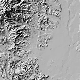
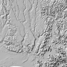
丹沢
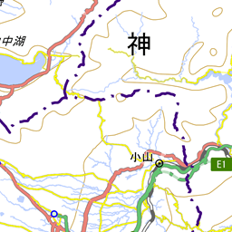
玄倉~山神峠~玄倉ノ野
2019年01月19日(土) [日帰り]

 kamog
kamog
- GPS
- --:--
- 距離
- 8.6km
- 登り
- 747m
- 下り
- 743m


| 天候 | 快晴 |
|---|---|
| 過去天気図(気象庁) | 2019年01月の天気図 |
| アクセス |
利用交通機関:
自家用車
・無料(数十台駐車可) ・トイレ、登山届ポスト(松田警察管轄)は隣接の玄倉バス停にある |
写真

 拍手
拍手


小菅沢右岸径路への木橋が残っているが、その先はもう道としてはダメであろう


それより先の山神径路も上部で一般的には通過できない崩壊地があるので、この径路も途中までしか行けません


左手南西尾根手前から径路が下っている。
木にピンクテープ、そして水源の森の白杭があった。
木にピンクテープ、そして水源の森の白杭があった。


感想
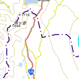
玄倉から山神峠、野(玄倉ノ野856m)を歩く。
秦野峠林道の蕗平橋から山神峠に至る小菅沢右岸径路は20年頃前は踏み跡も一部不明瞭ながらあったのだが、最近はほとんど消えているという他の方の話であったので、ひとつはそれを確かめるため、もうひとつは実はまだ歩いたことがない野(玄倉ノ野)の尾根を踏査することが目的。
噂通り小菅沢右岸径路は踏み跡もほぼ消失しているばかりか、途中横断する沢が特に中盤から上流は崩落しており、この径路は記憶によるともっと右岸の高いところを通っているはずだが実質通行不可といってよいであろう。
小菅沢の中を歩いた方が楽。この沢は堰堤オンパレードだが、一ヶ所右を巻くだけであとは左から巻ける。
820m二俣の右沢に入るとすぐ作業用単管橋(一部基盤の岩が浮いているが)があるので、そこから径路を辿れば山神峠に至る。
野(玄倉ノ野)の尾根は上部は開けて快適だが862m手前から太った植林帯となる。650mから派生する南西尾根手前から明瞭な径路をジグザグ下れば玄倉八幡神社に出た。
山神峠に至るルートはどこも崩壊しているせいか、人のほとんど来なくなった山神様がどことなく淋しそうであった。
お気に入りした人
1人
拍手で応援
拍手した人
23拍手
訪問者数:1240人


拍手
コメント
こっそり拍手
コメント
この記録に関連する登山ルート
この場所を通る登山ルートは、まだ登録されていません。
ルートを登録するこの記録で登った山/行った場所
関連する山の用語
山行記録を公開しました

情報提供のお願い

山登りをみんなが安全・安心に楽しむために、あなたの貴重な情報が役立ちます。
山行記録を投稿して、ヤマレコのコミュニティに参加しよう!
山行記録を投稿して、ヤマレコのコミュニティに参加しよう!
この山行記録の写真


玄倉野山の最新記録

玄倉第一発電所上部水槽からミツマタルート(崩壊で引き返し)
2025年04月05日 (日帰り) [C]

玄倉林道-雨山峠-山神峠-玄倉ノ野
2025年03月30日 (日帰り) [B]

往復バリで山神峠
2025年03月15日 (日帰り) [B]

玄倉ノ野ー山神峠ー伊勢沢ノ頭ー日影山周回
2025年02月22日 (日帰り) [B]

伊勢沢ノ頭 日影山 <マイナー登って降りて秋の花> 玄倉駐車場
2024年11月04日 (日帰り) [B]
大撫ノ丸の最新記録
玄倉第一発電所上部水槽からミツマタルート(崩壊で引き返し)
2025年04月05日 (日帰り) [C]
玄倉林道-雨山峠-山神峠-玄倉ノ野
2025年03月30日 (日帰り) [B]
往復バリで山神峠
2025年03月15日 (日帰り) [B]

玄倉駐車場~境隧道~山神峠~玄倉第八隧道~玄倉駐車場
2025年03月01日 (日帰り) [B]
玄倉ノ野ー山神峠ー伊勢沢ノ頭ー日影山周回
2025年02月22日 (日帰り) [B]


いいねした人
コメントを書く
ヤマレコにユーザー登録いただき、ログインしていただくことによって、コメントが書けるようになります。ヤマレコにユーザ登録する