ヤマレコなら、もっと自由に冒険できる

Yamareco

記録ID: 6416402
全員に公開
ハイキング
丹沢

大栂〜菰釣山:山伏歩道〜大栂南西尾根(仮称)

2024年01月29日(月) [日帰り]
 - 拍手
GPS
11:42
距離
17.4km
登り
1,320m
下り
1,316m

コースタイム

日帰り
山行
9:07
休憩
1:00
合計
10:07
6:45
13
山伏トンネル
6:58
6:58
22
7:20
7:20
32
7:52
7:57
18
8:15
8:15
49
山伏歩道分岐
9:04
9:04
8
9:12
9:12
8
水ノ木林道
9:20
9:20
11
9:31
9:31
10
廃バス
9:41
9:41
21
10:02
10:09
19
10:28
10:28
84
尾根取付き
11:52
11:52
40
織戸峠合流
12:32
12:38
53
13:31
14:13
19
14:32
14:32
24
14:56
14:56
16
15:12
15:12
22
15:34
15:34
23
15:57
15:57
18
16:15
16:15
9
16:24
16:24
16
16:40
16:40
12
16:52
山伏トンネル
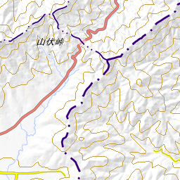
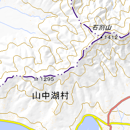
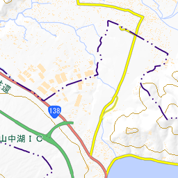
GPSログ取得に失敗したので、ルートは全部手書き。
天候 晴れ
過去天気図(気象庁) 2024年01月の天気図
アクセス
利用交通機関:
自家用車
山伏トンネル西側の旧道の路肩に駐車。
コース状況/
危険箇所等
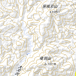
山伏歩道:
要所小屋ノ頭から南へとてもハッキリした道に沿って進み、西丸への登りの直前で、北側のトラバース道に入る。トラバース道はところどころ崩れていて注意が必要だが道跡は明瞭。明瞭な道を北東尾根から南東尾根を下り、沖ビリ沢に沿って進み、金山沢を越えて林道に出る。

水ノ木林道、樅ノ木林道、富士見林道:
ところどころ崩れている箇所もあるが、おおむね良好な状態で、歩く分には問題ない。

大栂南西尾根(仮称):
富士見林道の湾曲点の崖から取り付く、取り付きは急だが、その後は比較的緩い斜面の登りが続く。自然林の気持ちよい尾根で、980m付近で織戸峠からの尾根に合流する。踏み跡はほぼ付いていて、
合流してからはさらに明確になる。大栂への登りと菰釣山への登りはかなり急坂だが、緩やかな斜面になって三角点を過ぎると間もなく菰釣山の山頂に着く。
その他周辺情報 青根いやしの湯。冬季17時以降は550円。
山伏トンネル西側の旧道の路肩に駐車。この先は私有地で立ち入り禁止。
2024年01月29日 06:45撮影 by  Canon IXY 650, Canon
2
1/29 6:45
山伏トンネル西側の旧道の路肩に駐車。この先は私有地で立ち入り禁止。
山伏峠。
2024年01月29日 06:58撮影 by  Canon IXY 650, Canon
1/29 6:58
山伏峠。
木々の隙間から。
2024年01月29日 07:12撮影 by  Canon IXY 650, Canon
1
1/29 7:12
木々の隙間から。
大棚ノ頭。
2024年01月29日 07:20撮影 by  Canon IXY 650, Canon
1/29 7:20
大棚ノ頭。
高指山への分岐。
2024年01月29日 07:36撮影 by  Canon IXY 650, Canon
1/29 7:36
高指山への分岐。
要所小屋ノ頭。ここからハッキリした道を南尾根に入る。
2024年01月29日 07:52撮影 by  Canon IXY 650, Canon
1/29 7:52
要所小屋ノ頭。ここからハッキリした道を南尾根に入る。
山伏歩道のトラバース道の入口。西丸へは尾根上を進む。
2024年01月29日 08:15撮影 by  Canon IXY 650, Canon
1
1/29 8:15
山伏歩道のトラバース道の入口。西丸へは尾根上を進む。
ところどころ崩れているが道は明瞭。
2024年01月29日 08:17撮影 by  Canon IXY 650, Canon
1/29 8:17
ところどころ崩れているが道は明瞭。
こんな道。
2024年01月29日 08:23撮影 by  Canon IXY 650, Canon
1/29 8:23
こんな道。
ここから北東尾根に入る。
2024年01月29日 08:27撮影 by  Canon IXY 650, Canon
1/29 8:27
ここから北東尾根に入る。
少しザレた場所も。道はハッキリ右側に続いている。
2024年01月29日 08:39撮影 by  Canon IXY 650, Canon
1/29 8:39
少しザレた場所も。道はハッキリ右側に続いている。
沖ビリ沢との出会い。左岸の道を進む。
2024年01月29日 09:03撮影 by  Canon IXY 650, Canon
1/29 9:03
沖ビリ沢との出会い。左岸の道を進む。
金山沢との出会い。渡って対岸の林道に上がる。
2024年01月29日 09:09撮影 by  Canon IXY 650, Canon
1/29 9:09
金山沢との出会い。渡って対岸の林道に上がる。
苔生した廃林道。
2024年01月29日 09:12撮影 by  Canon IXY 650, Canon
1/29 9:12
苔生した廃林道。
寄り道して、樅ノ木林道の廃バスを見に行った。
2024年01月29日 09:30撮影 by  Canon IXY 650, Canon
2
1/29 9:30
寄り道して、樅ノ木林道の廃バスを見に行った。
樅ノ木橋。
2024年01月29日 09:47撮影 by  Canon IXY 650, Canon
1/29 9:47
樅ノ木橋。
菰釣橋。渡らずに左側の菰釣林道に入る。
2024年01月29日 10:01撮影 by  Canon IXY 650, Canon
1/29 10:01
菰釣橋。渡らずに左側の菰釣林道に入る。
大洞橋。渡って、右側の富士見林道に入る。
2024年01月29日 10:12撮影 by  Canon IXY 650, Canon
1/29 10:12
大洞橋。渡って、右側の富士見林道に入る。
富士見林道の湾曲点から強引に登って、尾根に取り付く。
2024年01月29日 10:27撮影 by  Canon IXY 650, Canon
1/29 10:27
富士見林道の湾曲点から強引に登って、尾根に取り付く。
ブナの巨木。裏側が縦に割れていた。
2024年01月29日 10:36撮影 by  Canon IXY 650, Canon
1
1/29 10:36
ブナの巨木。裏側が縦に割れていた。
気持良い尾根が続く。
2024年01月29日 11:25撮影 by  Canon IXY 650, Canon
1
1/29 11:25
気持良い尾根が続く。
織戸峠からの合流点。
2024年01月29日 11:52撮影 by  Canon IXY 650, Canon
1/29 11:52
織戸峠からの合流点。
急坂を登って、ようやく大栂山頂。
2024年01月29日 12:31撮影 by  Canon IXY 650, Canon
1/29 12:31
急坂を登って、ようやく大栂山頂。
気持良い尾根の急坂を上って行く。
2024年01月29日 12:58撮影 by  Canon IXY 650, Canon
1
1/29 12:58
気持良い尾根の急坂を上って行く。
緩斜面になった。
2024年01月29日 13:02撮影 by  Canon IXY 650, Canon
1
1/29 13:02
緩斜面になった。
菰釣山の三角点。
2024年01月29日 13:23撮影 by  Canon IXY 650, Canon
1/29 13:23
菰釣山の三角点。
菰釣山山頂。
2024年01月29日 13:31撮影 by  Canon IXY 650, Canon
1
1/29 13:31
菰釣山山頂。
すでに富士山には雲が。
2024年01月29日 13:58撮影 by  Canon IXY 650, Canon
1/29 13:58
すでに富士山には雲が。
こんな案内板が。
2024年01月29日 13:58撮影 by  Canon IXY 650, Canon
1
1/29 13:58
こんな案内板が。
山頂直下のブナの大木。
2024年01月29日 14:08撮影 by  Canon IXY 650, Canon
1
1/29 14:08
山頂直下のブナの大木。
山伏峠への長い稜線も気持ち良い自然林が続く。
2024年01月29日 14:22撮影 by  Canon IXY 650, Canon
1
1/29 14:22
山伏峠への長い稜線も気持ち良い自然林が続く。
ブナノ丸。
2024年01月29日 14:32撮影 by  Canon IXY 650, Canon
1/29 14:32
ブナノ丸。
油沢ノ頭。
2024年01月29日 14:56撮影 by  Canon IXY 650, Canon
1/29 14:56
油沢ノ頭。
樅ノ木沢ノ頭
2024年01月29日 15:12撮影 by  Canon IXY 650, Canon
1
1/29 15:12
樅ノ木沢ノ頭
鳥屋ノ丸。
2024年01月29日 15:17撮影 by  Canon IXY 650, Canon
1/29 15:17
鳥屋ノ丸。
西沢ノ頭。
2024年01月29日 15:34撮影 by  Canon IXY 650, Canon
1/29 15:34
西沢ノ頭。
石保土山。
2024年01月29日 15:57撮影 by  Canon IXY 650, Canon
1/29 15:57
石保土山。
撮影機器:

感想

未踏の山伏歩道を下り、大栂南西尾根(仮称)から大栂、菰釣山を周回してきた。
少し長くて急登がキツかったが、ブナの多い自然林がとても素晴らしくて気持ちよい山歩きができた。

お気に入りした人
拍手で応援
拍手した人
拍手
訪問者数:165人

コメント

まだコメントはありません
プロフィール画像
ニッ にっこり シュン エッ!? ん? フフッ げらげら むぅ べー はー しくしく カーッ ふんふん ウィンク これだっ! 車 カメラ 鉛筆 消しゴム ビール 若葉マーク 音符 ハートマーク 電球/アイデア 星 パソコン メール 電話 晴れ 曇り時々晴れ 曇り 雨 雪 温泉 木 花 山 おにぎり 汗 電車 お酒 急ぐ 富士山 ピース/チョキ パンチ happy01 angry despair sad wobbly think confident coldsweats01 coldsweats02 pout gawk lovely bleah wink happy02 bearing catface crying weep delicious smile shock up down shine flair annoy sleepy sign01 sweat01 sweat02 dash note notes spa kissmark heart01 heart02 heart03 heart04 bomb punch good rock scissors paper ear eye sun cloud rain snow thunder typhoon sprinkle wave night dog cat chick penguin fish horse pig aries taurus gemini cancer leo virgo libra scorpius sagittarius capricornus aquarius pisces heart spade diamond club pc mobilephone mail phoneto mailto faxto telephone loveletter memo xmas clover tulip apple bud maple cherryblossom id key sharp one two three four five six seven eight nine zero copyright tm r-mark dollar yen free search new ok secret danger upwardright downwardleft downwardright upwardleft signaler toilet restaurant wheelchair house building postoffice hospital bank atm hotel school fuji 24hours gasstation parking empty full smoking nosmoking run baseball golf tennis soccer ski basketball motorsports cafe bar beer fastfood boutique hairsalon karaoke movie music art drama ticket camera bag book ribbon present birthday cake wine bread riceball japanesetea bottle noodle tv cd foot shoe t-shirt rouge ring crown bell slate clock newmoon moon1 moon2 moon3 train subway bullettrain car rvcar bus ship airplane bicycle yacht

コメントを書く

ヤマレコにユーザー登録いただき、ログインしていただくことによって、コメントが書けるようになります。
ヤマレコにユーザ登録する

この記録に関連する登山ルート

この場所を通る登山ルートは、まだ登録されていません。

ルートを登録する

この記録で登った山/行った場所

関連する山の用語

この記録は登山者向けのシステム ヤマレコ の記録です。
どなたでも、記録を簡単に残して整理できます。ぜひご利用ください!
詳しくはこちら